|

|
|

(PART ONE)
Lookin' for Adventure . . . and Coffee
by John Hauck
 It's been a long time coming. It's been a long time coming.Today
I'm going to start my flight 'round the border of the USA! It's time to go. Miss P'fer
("P" for plane) is loaded down, fueled up, ready for takeoff. I'm ready to
firewall the throttle as soon as I wipe these tears from my eyes so I can see to fly.
PHOTO: Mountains under my wing near
Muncho, British Columbia. Remember, I'm following the recommended VFR route on the
Canadian Supplement, so I'm not far off the road if an emergency landing is needed.
BELOW: Gantt International Airport, Titus, Alabama. Loaded and ready to begin my 41-day
adventure. This is truly an international grass strip, 600 feet long. Many flights have
been initiated here that ended up over Canada and Mexico, in my Firestar and Mark III.
 My son Mike and my special friend
Nell are waiting by the hangar for me to depart. This moment of emotion has taken me by
surprise. Now I'm ready. Throttle slowly full open, 5400 rpm, about 50 mph and Miss P'fer
is off the wet grass and flying at 0830, 7 June 1994. One orbit around Gantt International
Airport, my 600-foot grass strip and we (Miss P'fer, my Kolb Mark III, and I) are heading
southwest for our first stop at Ronnie Smith's place (South Mississippi Light Aircraft)
near Lucedale, Mississippi. Miss P'fer climbs slowly, not her normal performance. She's
carrying nearly her own weight in fuel, cargo and pilot; more than 1100 pounds gross. She
will fly this way until we return home. My son Mike and my special friend
Nell are waiting by the hangar for me to depart. This moment of emotion has taken me by
surprise. Now I'm ready. Throttle slowly full open, 5400 rpm, about 50 mph and Miss P'fer
is off the wet grass and flying at 0830, 7 June 1994. One orbit around Gantt International
Airport, my 600-foot grass strip and we (Miss P'fer, my Kolb Mark III, and I) are heading
southwest for our first stop at Ronnie Smith's place (South Mississippi Light Aircraft)
near Lucedale, Mississippi. Miss P'fer climbs slowly, not her normal performance. She's
carrying nearly her own weight in fuel, cargo and pilot; more than 1100 pounds gross. She
will fly this way until we return home.
The weather is marginal VFR, ceiling barely 1,000 feet. I have a
sensational feeling once airborne. All the work, worry, frustration, planning and
preparation is over. But, my "free at last" feeling won't last. Thirty minutes
into my flight I am being pushed down by extremely low clouds. Not enough clearance
between me and the tops of those tall pines. I make the decision to land and wait out the
weather at Prattville Airport.
My flight will take me south to the Gulf of Mexico, down the east
coast of Texas to Brownsville, up the Mexican border to San Diego, California, up the West
Coast to Arlington, Washington, into Canada at Abbotsford, British Columbia, up the Fraser
Canyon to Dawson Creek, BC (mile "0" of the Alaskan Highway), up the Alaskan
Highway to Fairbanks, Alaska, up the Dalton Highway (pipeline haul road) to Dead
Horse/Prudhoe Bay, Alaska on the Arctic Ocean. From Dead Horse back to Fairbanks, west to
Mount McKinley, south to Anchorage, east to Tok, then backtrack all the way to Arlington,
Washington. From Arlington, east to the northeast corner of Maine, down the East Coast to
Key West, Florida, up the west coast of Florida and back home to Alabama.
 After a call to Flight Service and one hour on
the ground, I was on my way again. The weather delay was good. It gave me time to settle
down to the job at hand, to get into the right frame of mind to fly. The low ceiling broke
up. I climbed to altitude looking for favorable wind. There were beautiful white, fluffy
clouds and blue sky all around. I was in my element. After a call to Flight Service and one hour on
the ground, I was on my way again. The weather delay was good. It gave me time to settle
down to the job at hand, to get into the right frame of mind to fly. The low ceiling broke
up. I climbed to altitude looking for favorable wind. There were beautiful white, fluffy
clouds and blue sky all around. I was in my element.
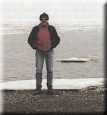
PHOTO: A self portrait during the trip.
The little Rotax 912 was singing its song at 5,000 rpm. The Warp
Drive carbon fiber, tapered 3-blade prop was doing its job pushing me, Miss P'fer, and our
cargo (everything we needed to survive from the Tropics to the Arctic) along at 80 mph. It
wasn't easy packing wool boot socks, Thermax turtleneck shirts, Gore-Tex gloves, down
filled vest, polypropylene thermal underwear and warm-up suits when it was 100 degrees
outside. But later into my flight I was glad I did.
I didn't think I would ever wear my leather flight jacket, until I
found out it gets pretty cold in Northern California. I had 4 pairs of blue jeans, 7
t-shirts, underwear, and socks, two towels for me and two for Miss P'fer. One pair of
hiking boots, deck shoes, running shoes and shower shoes. I had a 3-man tent, air
mattress, sleeping bag, pillow, two survival blankets (one to use as a ground cloth, the
other to cover the seats when the aircraft was tied down to keep the seats dry). Miss
P'fer's door hinge line leaks into both seats. I had freeze dried rations, trail mix,
mixed nuts, "Power Bars," granola bars, coffee, dehydrated soup, 3 quarts of
water, 3 quarts of Coleman fuel for the pack stove, pots and pans, shaving kit, medicine,
star-light mints (helped keep me awake; also used as rewards as I flew off the hours),
long and short sets of tie down stakes, survival rifle and ammo, 35 US and Canadian
sectionals, one Alaska and one Canada Flight Supplement, one quart of peanut butter,
knives, two cameras, 30 rolls of 35 mm film, poncho, tool kit, 8 spare spark plugs, wax
and rags (primarily for windshield and door maintenance), small spare parts, insect
repellent and net, first aid kit, one quart engine oil (which I never needed to add
between oil changes), Rand-McNally Road Atlas, pilot and aircraft log books, and a large
package of documents to get me and Miss P'fer through Canada, and more small items of
survival gear.
Before you know it, we're setting up to land at Ronnie Smith's long
grass strip. Prelanding check complete, chop the throttle and pull in two notches of
flaps, and we're on the ground and shutting down in front of Ronnie's hangar. He tops Miss
P'fer off with 12 gallons of 92 octane mo-gas. We chat a minute. He won't accept any
payment for the fuel. I don't argue, climb back in Miss P'fer, and fly west.
When I land at Picayune Airport for lunch, the "airport
bums" sitting in the shade of the front porch of the FBO all want to know what I'm
flying, where I'm from and where I'm going. They're amazed that I've flown the little
aircraft this far and are astounded that I'm flying around the border of the US with a
dog-leg to Dead Horse, Alaska on the Arctic Ocean. I'm amazed and astounded also. This is
7 June 1994, the first half-day into a 41-day solo flight that will cover 17,400 statue
miles in 231.2 flight hours. Yep, I'm also having a hard time comprehending this trip.
Eight hours after I left home, I was tying Miss P'fer down at the
Beaumont, Texas Airport. My first day had been good. I flew 529 miles and had no problems.
The FBO was a Vietnam vet, Army Helicopter pilot, just like me. He let me sleep on the
couch in the pilot's lounge. There was a shower with lots of hot water. I ate trail mix
and mixed nuts for supper, washed down with a diet Pepsi. I hoped this day would be a
trend for the rest of my trip.
DAY 2
I was up and flying before anyone arrived at the airport. I flew
southwest over oil wells, drilling rigs, and salt marshes until I hit the beaches on the
Gulf of Mexico. I low-leveled just off the beach, popped up to about 1,500 feet to cross
Galveston Pass, then back down again along the beach to Galveston Airport. I tied down
next to Base Ops for Petroleum Helicopters. Val Martinez, retired Army helicopter pilot/VN
vet, came out to the plane and helped me move it so I wouldn't get blown away by the
rotary wing traffic. He helped me tie Miss P'fer down, gave me instructions to a nice
restaurant and loaned me his car.
After leaving Galveston, I saw my first DEA (Drug Enforcement
Authority) Aerostat tethered at 7,500 near Matagorda, Texas. From that altitude it was a
long descent to Port Lavaca and Calhoun County Airport for fuel. I took on 20 gallons and
continued down the East Texas coast. From Corpus Christi to Brownsville was 120 miles of
sand dunes and salt water. I stayed high, 8,500 feet, to benefit from the smooth, cool
air. I was tired and hungry. I refueled Miss P'fer first, then got a car and a good supper
in Brownsville. Two hours out of Brownsville it was getting dark, I was tired and Zapata
County Airport beacon was on the horizon.
There's not much population in Southwest Texas, but there is a lot
of mesquite, sand and cactus. When I transmitted my intentions to land, I didn't expect to
get a traffic advisory from the Zapata FBO, but I did. Mike, the FBO's assistant, helped
tie the airplane down, shared his fresh fried fish supper and let me sleep on the floor of
the FBO next to the air conditioner. Really hospitable people.
DAY 3
It's 0800 hours and I'm on my way. Over Laredo and on to Eagle Pass.
I'm in luck; the airport is right down town. I love it. I can see Burger King's sign from
where I park my plane. I use the bathroom at the FBO. No one speaks. I walk to Burger King
for lunch, return to my plane and no one says a word. I fill up my water bottle in the
bathroom, go back to my plane and fly out of Eagle Pass. Those folks just weren't
interested in me or my strange red and yellow ultralight from Alabama.
I flew the rest of the afternoon, got knocked around in the hot
desert thermals, flying 8,500 MSL over terrain about 4,000 MSL. I landed well before dark
at Fabens, Texas and spent the night on the warm tarmac under Miss P'fer's wing.
DAY 4
I turned the corner at El Paso and was in New Mexico -- my first
visit. By the time I landed at Deming, New Mexico, the big 800x6 mains were white half way
up their side walls. You see, I was fascinated with the desert, a place I had never been.
I had an irresistible urge to touch it. I found a very small dry lake, we'd call it a pond
in Alabama, drug it and landed. I was afraid to shut the engine down in this desolate
spot. But to really feel the desert, I had to turn it off. I did. It was awfully quiet. I
got out, took some pictures, looked around, got back in, crossed my fingers and hit the
starter. The 912 came to life immediately and I took off for Deming, where I had my first
coffee of the day. The Deming FBO is number one!
PHOTO: Right, On a very large dry lake
east of Deming, New Mexico.
Below, What a dry lake looks like close up -- and to prove I was really
there!
 From Deming, I pushed on to Tucson, landing at Avra Valley
Airport. Right next to the FBO is a restaurant. I used the bathroom in the FBO and
discovered a shower. I asked the young lady at the desk if I could take a shower and she
said, "sure." First bath since Beaumont, Texas, day one. From Deming, I pushed on to Tucson, landing at Avra Valley
Airport. Right next to the FBO is a restaurant. I used the bathroom in the FBO and
discovered a shower. I asked the young lady at the desk if I could take a shower and she
said, "sure." First bath since Beaumont, Texas, day one.
It was hot in Tucson, over 100, but an hour and a half later on the
ground at Gila Bend, Arizona, it was hotter, 112 degrees. Even the natives were
complaining. The high elevation and temperature took its toll on aircraft performance,
too. I had to carry another 10 mph on landing.
My next leg was 170 miles, nonstop to El Centro, California, 56 feet
below sea level. I had a good supper, slept under the stars on a little patch of grass
next to the terminal.
DAY 5
Up at daylight, free coffee and doughnuts at the motel next door,
and we're on our way to San Diego. Boy was I excited! I had flown my little
ultralight-type aircraft to California the long way. In about an hour, I would be seeing
the Pacific Ocean, or so I thought.
PHOTO: Avra Valley Airport near Tucson.
It was 100 degrees when I landed here.
Out of El Centro, over NAF El Centro, and back over the desert and
mountains along the Mexican border. Flying over NAF El Centro was significant to me. In
1963, my brother Jim Hauck was a member of a US Army Special Forces HALO (High
Altitude/Low Opening) Team that broke the World Team Altitude record held by the USSR. The
record jump from 43,500 feet stands today, to the best of my knowledge.
Less than 15 miles from Brown Airport, San Diego, I encountered
Pacific marine coastal fog. The Pacific coast was socked in. I was disappointed. I did a
quick map reckon, radioed Flight Service and found the nearest VFR airport with fuel was
Borrego Springs. The beautiful flight to Borrego Springs helped soothe the disappointment
of not seeing the Pacific. Besides, I got to see a road runner eat hamburger balls on the
FBO's desk in Borrego.
I wanted to visit my niece in Los Angeles. Perris Valley Airport
looked like a good place from which to call her. Besides, there was an ultralight symbol
next to it on the LA sectional. At 6,500 feet, I was looking at what I thought was solid
overcast. On top I could see the ground. Horizontal visibility was zero. Vertical was
marginal. I called Perris Valley Unicom to check the weather. No sweat, they were dropping
jumpers. Once below the LA smog layer, I still had to contend with the ground fog. With
patience I was able to find my way through it, made my radio call to Perris Valley traffic
and landed on the paved strip. At the other end of the field was the ultralight area. A
big California dude in a 4x4 motioned for me to follow him. I was impressed at this
operation. They were escorting me to my parking ramp! As soon as I shut down, the big
California dude promptly informed me ultralights weren't allowed on the real airplane
runway. I tried to explain that I was a new guy from Alabama, this was an experimental
registered light plane, and I had called my intentions to Unicom before I landed. That
didn't matter. I looked like an ultralight. I had to use the UL strip. I didn't argue. I
found a telephone, my niece wasn't home. I drank a Coke, said hello to a few people, got
back in my plane and headed north.
Now, all I had to do was get out of the LA basin without getting run
over by a DC-10 or fly into a mountain. I low leveled east around March AFB, climbed out
over San Bernardino and over the mountains at 8,500 feet. I needed a pit stop. The
sectional showed Hesperia on the north side of the mountain. The wind was picking up. I
had my hands full making a cross wind landing at 3,390 feet on hot asphalt with low
pressure 800x6 tires.
The FBO was closed for lunch. In my search for a bathroom I found a
restaurant. I hadn't had a bite to eat since that doughnut at El Centro. What a find! I
had a New York strip steak and a lot of iced tea. The waitress let me have a double table
to spread my sectionals and do flight planning to Arlington, Washington. I had gotten
ahead of myself when I left El Centro. I took several hours in the air conditioning to
prepare myself for the afternoon's flight in the desert.
Off from Hesperia and northwest over El Mirage Dry Lake, cut the
corner of Edwards AFB, across the mountains and over Bakersfield. Just before dark, I made
it into Corcoran. This is farm country and the airport was an ag strip. I slept under the
wing on the concrete ramp. There was no place to eat so I had trail mix, mixed nuts and
washed it down with water. Several times during the night I was awakened by the beautiful
sound of big round engines on Ag Cats as they shuttled in and out during the night to
spray crops.
DAY 6
Up early and out of Corcoran. A beautiful flying morning. I landed
at Fresno for breakfast, but there was none. I had to fly 125 miles to find coffee at
Turlock Airport. John Fletcher made me feel right at home. I picked up 10 gallons of
mo-gas on the return from the restaurant. I didn't have a chance to burn mo-gas very
often, but when I could, I did. It saved 75 cents to a dollar a gallon over LL. Before I
left Turlock, John presented me with an automatic siphon hose (an Alabama credit card). I
carried it with me for the rest of the trip.
My next stop was Sonoma Sky Park north of San Francisco. Again I was
disappointed. I could see the tops of the towers of the Golden Gate Bridge above the fog,
but no Pacific Ocean. I visited for a while at Liberty Field and headed for Ukiah to
refuel, but couldn't land because of an airshow. I had to fly to Willets, 25 miles north.
Willets Airport is situated on the side of a mountain. There is a
wind sock at the north end and one at the south end of the field. I had to flip a coin to
see which way I should land since one sock pointed north and the other south. I chose to
land to the south. Later I learned one always lands to the north when the socks are
opposite.
The FBO was closed. Everyone had gone to the airshow at Ukiah. It
was still early enough to fly several more hours, but I didn't have enough fuel to make it
to Eureka. I had to either backtrack to Ukiah or wait until someone opened up the FBO. I
didn't want to backtrack, so I decided to stay.
I found out quickly that it is much cooler in northern California
than it is in southern California. I figured it would be a good time to put up my tent and
cook some freeze dried rations since I had plenty of time on my hands. I was in an
isolated place in the mountains, but there were a lot of homes up here. I had many
visitors that evening. One gentleman brought me a homemade burger and a Pepsi. Another
offered me a shower in his home. They were all very nice. I got a good night's sleep, got
up early, packed my gear, refueled Miss P'fer and just barely beat the marine fog that was
coming over the mountain.
DAY 7
I flew north up Highway 101. I wanted to fly up the coast, but
Eureka was socked in. South of Barberville, I ran into weather. I turned northeast over
tall trees on high mountains. Shortly I had to find a restroom, and the cold mountain air
was not helping. I saw Hay Fork on the sectional and headed for it. We literally dropped
into Hay Fork. The town was within walking distance, so I set off walking down the road,
over the river on a pedestrian suspension bridge and up the hill to Irene's Cafe. As I was
walking along in the northern California mountians, it was hard to believe that I had
gotten here in that little plane. It was exciting.
Out of Hay Fork, I could see Mount Shasta, 14,162 feet, 60 miles to
the northeast. The wind was really ripping, 25 to 30 mph. I passed up Weed Airport as
there was no crosswind strip and the wind was overpowering my rudder. I made it into
Montague, refueled, had coffee, made phone calls, then headed north.
I didn't fly far -- 33 miles. The wind was beating me up pretty
badly and the forecast was for more of the same. I didn't fly across the Oregon border, I
was blown across it. I talked to Ashland, Oregon Unicom. They had wind 25 gusting to 35,
but it was blowing straight down the runway. I hovered to a landing. I only flew 4.2
hours. It was windy, cold and spitting rain. I opted for a motel, a hot shower and a hot
meal.
DAY 8
After the beating and short flying day yesterday, I was determined
to get an early start. At daylight I stuck my head out the door, not a leaf stirring. But
it was cold, 38 degrees. I hadn't asked for an early ride the night before, so I
decided to walk to the airport with my three bags rather than lose the early air time.
With the aircraft loaded, I hit the starter but the battery was too weak to turn the 912
at 200 rpm required to fire the plugs. It was 0600; there wasn't anyone else at the
airport. I was thoroughly disgusted with myself for not buying a new battery for my trip.
A car came in the airport and straight for me. A man got out to take a look at Miss P'fer.
He had a pair of jumper cables and I had an engine start. I took his picture standing next
to my plane and thanked him.
The ceiling was not as high as I would have liked it, so I generally
followed I-5 and took a coffee break at Grant's Pass. The weather wasn't getting any
better, but it was still flyable. Fifty miles north was Roseburg. The sectional showed the
airport symbol overlapping the town, a good indication I would find a place to eat within
walking distance of the airport. I was ready for a northwoods breakfast. I landed there,
got a ride into town, had breakfast and had to walk a good deal out of my way to get back
to the airport because of road construction, but I needed the exercise anyhow.
I could forget about flying the Pacific coast. The weather was
lousy. I continued north, hoping to make Arlington, Washington before dark.
The folks at Arlington took good care of me. I stayed three days,
which gave me a chance to rest up and prepare for my next big step, going into Canada, and
visit with one of my Special Forces Army buddies and his family. Jim and Betty Scott
graciously came to my rescue, realizing my situation and offering me Betty's personal car
for the two days I spent in the Seattle area.
DAY 11
I spent most of the day preparing for Canada and Alaska. By late
afternoon I was ready. I filed for Abbotsford British Columbia and was in the air at 1700.
An hour later, I was on the ground waiting to go through Customs.
The female customs inspector looked at everything I owned. Flight
Service thought I had plenty of time to make it to 100 Mile House before dark. That's
where I filed. Night VFR is not authorized in Canada.
 Off Abbotsford, up the Fraser River
past Chilliwack to Hope. Hope is the beginning of the Fraser River Canyon bordered by
6,000 to 9,000 foot mountains. The mountains form a "V" right down to the river.
The highway and railroad clings to the near vertical sides of the mountains right over the
river, then disappear into the numerous tunnels. The Fraser River Canyon is noted for its
extremely turbulent, unpredictable winds and weather. I lucked out. I had "field
grade" weather right up the canyon. Off Abbotsford, up the Fraser River
past Chilliwack to Hope. Hope is the beginning of the Fraser River Canyon bordered by
6,000 to 9,000 foot mountains. The mountains form a "V" right down to the river.
The highway and railroad clings to the near vertical sides of the mountains right over the
river, then disappear into the numerous tunnels. The Fraser River Canyon is noted for its
extremely turbulent, unpredictable winds and weather. I lucked out. I had "field
grade" weather right up the canyon.
PHOTO: Heading up the Fraser River
Canyon just outside Hope, British Columbia.
The photo's a little hazy, but that's what the conditions were.
Entering the canyon is not only beautiful, but awesome. There's snow
on the mountains in June. There's no place to land if you loose an engine. It made me and
my airplane feel extraordinarily small and expendable. As I got further into this leg, I
realized I was going to have a problem. It didn't look like I was going to make it to 100
Mile House before dark. The airport was not lighted and the runway terminated downtown.
Clinton, 35 miles south of 100 Mile House has a gravel, unlighted strip. I shot an
approach into Clinton to see if it was feasible to return and land after dark. The strip
is on a low mountaintop and would be easy to find in the dark. There was still a chance to
make 100 Mile House.
Fifteen miles further it got dark. (I think it gets dark quicker in
British Columbia.) On top of darkness (my airplane is licensed for night flight in the
U.S.) I had to close my flight plan or the Royal Mounties would come looking for me. I
couldn't raise Flight Service on the radio and there were absolutely no facilities of any
kind at Clinton. I kept trying on my return and finally got an answer and closed it. I
made a good night landing into Clinton between bushes and taxied around until I found a
good place to put up my tent. I got out of the plane and was overcome by my first taste of
northwoods mosquitoes. They were so bad I forgot how cold and hungry I was. Through it
all, I got the tent up and my gear inside. Once inside with the little candle lantern
burning, air mattress and sleeping bag rolled out, I was feeling much better. I ate nuts
and trail mix, filled out my log books and got a good night's sleep.
PHOTO: Muncho Lake,
British Columbia.
 DAY 12 DAY 12
I'm up at daylight, rolled and loaded my gear, and took off for 100
Mile House under a low ceiling. Halfway to my destination, the ceiling went right down to
the deck. I was getting low on fuel so I couldn't play games with the weather. I landed at
Green Lake, a private strip just east of my location. On the ground I stayed in the plane
to keep warm and occupied myself looking at charts and watching the community of prairie
dogs watching me. I was thinking more and more of hot coffee and breakfast. I decided to
give it a try. I firewalled the throttle and started my ground roll. The engine missed and
didn't come up to full power. I got the wheels off the ground hoping it would clear out,
but it didn't. Chopped the throttle and aborted the take off. The airstrip was uphill with
tall trees at the departure end. Back on the ground, I ran the engine as hard as the
brakes would hold it, and it seemed to clear some. Mag check was okay, so I taxied to the
opposite end of the strip to make a downhill departure with no trees at the end. It missed
a little and was low on normal takeoff power, but I had an option if it quit this time. A
minute or two into the flight, and it cleared up. I got over the hill and into a river
valley that would get me under the weather and into 100 Mile House.
There was no one at the airport. The gas pump was locked. This
didn't look like it was going to be a good day!
About this time I was feeling sorry for myself, wondering what I was
doing way up here in this little airplane when up drives my savior, Robert G. Franklin.
Robert asks if he can help me. Wow! Yes, I need fuel. He recommended we go to the service
station for mo-gas because the airport fuel was old and full of water. He uses mo-gas in
his Piper. He took me for gas, bought my breakfast, and let me use his telephone. By this
time the weather had lifted a little and I was on my way. Today is going to be a good day
after all!
Fifty miles north of 100 Mile House and we're over Williams Lake.
Navigation became very simple after I departed Abbotsford -- just follow the rivers and
highways marked on the Canadian Sectional with closely spaced small blue diamonds, the
recommended VFR route. I like following the river and in no time I'm ready for a quick
stop at Quesnel. I taxi up to the terminal and am informed by the gentleman in Flight
Service that ultralights are not allowed to land at this uncontrolled airport. I told him
I was a US registered Experimental and could I please use his restroom since I was already
here on the ground.
Sixty miles north, I wasn't ready to land, but Prince George was the
last available fuel until Dawson Creek, 250 miles north. Prince George is a large
controlled airport with not only fuel, but food. I took advantage of both. The tower
operator informed me ultralights weren't allowed. Same old story as Quesnel. Strange? He's
the guy that cleared me to land.
I flew along beautiful lakes and rivers for 95 miles north. I saw my
first bald eagle soaring over a lake and took some time to fly with him. He was
magnificent, a much better aviator than I. I took his picture, but missed him -- you
see, he was making these real tight turns and . . .
 PHOTO: Dawson Creek,
British Columbia, and my first "night" of 24 hours of daylight. PHOTO: Dawson Creek,
British Columbia, and my first "night" of 24 hours of daylight.
I turned east into the mountains and followed the trench 93 miles to
Chetwynd. I didn't want to stop, but Mother Nature insisted. I met the weather station
operator who was also the mayor. She asked me to stay, but I was anxious to make Dawson
Creek before dark. I found out that it wouldn't get dark at Dawson Creek that night; in
fact, I wouldn't see darkness again until I was on my return leg south.
I cleared the mountains east of Chetwynd and flew direct to Dawson
Creek. There was no ride to town for supper. I refueled Miss P'fer, taxied to the
campground, pitched my tent, boiled some water for a freeze dried meal, relaxed and
planned for my flight up the Alaskan Highway. I had no problem going to sleep with the sun
shining on my tent. I was tired.
* * * * * * * *
Editor's note: Next month, we'll continue with John Hauck's
journey up the Alaskan Highway over some of the most spectacular scenery a human ever has
the privilege to see, including his dog-leg trip along the barren pipeline highway to
Prudhoe Bay. It's not a trip for the timid of heart, but with good planning and using good
common sense, it's a trip that can be made.
|
|
(PART TWO)
Lookin' for Adventure . . . and Coffee
by John Hauck
| Editor's Note: When we last left our intrepid traveler, John
Hauck, he had just pitched his tent and settled in for his first night of 24-hours of
daylight at Dawson Creek, British Columbia. Following the Alcan Highway, Hauck's about to
reach the half-way point of his trip when he lands at Prudhoe Bay, on the coast of the
Arctic Ocean, his turnaround point to complete his 'round the border of the US flight in
his Kolb Mark III. Day 13
I didn't take time to make coffee, just packed up and headed north.
I planned to stop at Fort St. John, 40 miles north, for breakfast and coffee, but St. John
didn't have breakfast, just a coffee pot in the FBO. That was enough to keep me going
another 100 miles to Mae's Kitchen. Mae's is within walking distance from the Sikanni
Chief emergency airstrip, one of several World War II gravel strips near the Highway.
PHOTO: Mae's Kitchen near Toad River, right
along the Alcan Highway.
Just out of Fort Nelson, I was heavy into beautiful mountains. As I
was flying low over an old section of highway, I flew right over a black bear on the
shoulder of the road. I circled back and captured him on film. Didn't bother him a bit;
this was his road and he kept on walking just like he owned it.
As I flew over Summit Lake, east of Toad River, the afternoon winds
were hitting me from three directions at once, and I was facing a terrific headwind. As we
flew around the corner of a mountain, there was the Toad River airstrip! I was glad to get
Miss P'fer on the ground; we'd made just over 400 miles so far today. After a bite to eat,
we're ready for another 400.
As the afternoon progressed, so did the wind. We were flying in a
trench all the time. The turbulence was really bad. The wind was really starting to beat
me up. I had flown 500 miles today and really wanted to get to Watson Lake, but the Liard
River emergency airstrip was just north of my location and looked like a good choice. I
called Flight Service to cancel my flight plan, but I couldn't raise them. I had no choice
but to make radio contact. There are no facilities at Liard River emergency strip, and I'm
too tired to fly another 150 miles in this rough air. I keep trying to make contact. Then,
Bonanza 89G asked if he could relay a message for me. He is somewhere over my position. I
asked him to close my flight plan. He did so. I thanked him, drug the Liard River airstrip
and set up for my landing. It's right on the banks of the Liard River, 34 miles south of
the Yukon Territory border. There was no one there but me, Miss P'fer, a large windsock
and some large moose hoof prints. I was beginning to realize the meaning of desolation as
I set up my tent and got ready to go to bed.
I heard a car coming as I entered my tent, and that startled me a
little. I thought I was way out here all by myself. The car drove up the hill off the
airstrip and in the bushes where I had Miss P'fer parked and my camp set up. An Indian and
his wife and young daughter got out. We visited and they invited me to stop on my way
back, saying there'd be 300 campers there for a Tribal Council meeting. They asked me
about my trip and invited me to stop by their home in Lower Post, south of Watson Lake.
Day 14
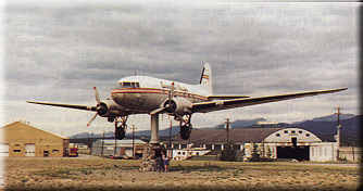 PHOTO: How's
this for a drawing card... a DC-3 on a wind tee at Whitehorse, Yukon Territory. PHOTO: How's
this for a drawing card... a DC-3 on a wind tee at Whitehorse, Yukon Territory.
On my way out of Liard River, I flew around the little village of
Lower Post, but couldn't find my Indian friend's car or house. On to Watson Lake, for an
early breakfast... and coffee, except there's no coffee or hot breakfast. After a call
downtown to the fuel man, I'm refueled and told that Rancheria, 85 miles to the north, has
a cafe, fuel, motel and campground... and it's okay to land on the highway. An hour later,
I'm taxiing up to the cafe at Rancheria. After breakfast and some pictures of me and my
airplane on the highway for some fellow travelers, we're headed up the highway to
Whitehorse, 200 miles north.
It's cold, windy and damp in the Yukon Territory. Temperatures are
averaging 40-50 degrees, which is unreal to an Alabama boy in June! OATs this low causes
my engine oil temperature to run below 180 degrees. It should maintain 190 to 235 degrees
to be in the green and do its job of cooking off condensation and contaminants from the
remote oil tank. I took time to bypass the cooler. I changed two oil lines, the cooler is
bypassed, the inlet and outlet of the cooler closed. The bypass worked. Oil temp was
running 210 degrees, middle of the green.
Another 120 miles, Whitehorse Tower is clearing me to land. I touch
down on a wet concrete runway. It's drizzling and cold. After taking care of Miss P'fer, a
good meal and a picture of the world's largest wind tee -- a Douglas DC-3, I file my
flight plan to Haines Junction, 100 miles north. Halfway there I hit an updraft and an
immediate downdraft so violent, it shut the engine down momentarily. Probably caused by
carburetor floats shutting off the fuel. The engine caught right back up as soon as we got
positive, but everything that was loose in the cockpit bounced off the top. I wanted to
find out what the winds were at Haines Junction, but Unicom didn't answer. It really
didn't matter, though; I had to land. I didn't want to fly any more in this wind.
The landing itself was exciting. The threshold was on a high bank
over the river. A local bush pilot helped me tie down, amazed that I was out flying. He
didn't recommend continuing up through the Pass tonight, so I made myself at home in the
foyer of the terminal. It was warm and dry, and there was a telephone to call home.
Day 15
I filed for Beaver Creek, Yukon Territory, 180 miles north, the last
airfield before the Alaskan border. It's 280 miles to Northway, Alaska. Flight Service
says there's fuel and food at Mile 1118 -- a service station on one side and a cafe on the
other.
Thirty minutes out of Haines Junction, I was snuggled up to a 7,850
foot mountain that rose 5,000 feet in two miles. I had been told by the bush pilot the day
before to look for Dall sheep in this area, and it didn't take long to find them. They
stick to the sides of what seem like cliffs. This was my first sighting of Dall sheep.
Big, white, beautiful creatures in a world all their own.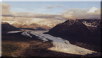
I climbed over the first ridge at 8,600 feet, to see my first
glacier. Down below was the beautiful turquoise water of Kluane Lake. To the south was
gray rock, ice and snow. What a contrast! I turned back up the highway looking for Mile
1118, and checked it out for a highway landing. My checklist for highway landings was as
follows: 1) Be able to see both ways far enough to stay clear of 18-wheelers and big RVs;
2) Check for power lines; 3) Check for highway signs and markers; and 4) Check trees and
tree limbs near the highway.
PHOTO: The Matanuska Glacier.
By the time I got Miss P'fer refueled on one side of the highway, a
bus load of tourists had invaded the cafe on the other. Forget coffee and breakfast. I
bummed a cup of coffee from the service station, answered questions and was off for Beaver
Creek, my last stop before Alaska.
I filed my next flight plan by telephone from Beaver Creek to
Northway, 64 miles. Flying low level up the highway, I was part of the wagon train of
18-wheelers, travel trailers and motor homes.
It wasn't difficult to find the Alaskan border. A wide, clear cut
swath as far as the eye could see. I was elated. I couldn't believe I was in Alaska at
last. Another hour and I would touch down at Northway Airport. It took a few minutes to go
through customs; cost $25.00.
Northway is a small community built up around the airstrip. There's
a post office, motel, cafe, general store, flight service station, and US Customs Offices.
I had a big Alaska breakfast with lots of coffee. On the parking ramp, I heard someone
say, "That little Alabama dog is going to get cold, way up here in Alaska." I
looked up and there was Jack Hale, his wife and their little white toy poodle. Jack is a
friend from EAA Chapter 822, Montgomery, Alabama. They were on their way to visit family
in Anchorage. Jack's Beechcraft and another, 89G, had arrived from Whitehorse about an
hour after I landed. Beech 89G was flown by two gentlemen from Argentina. Both Beech
aircraft had been weathered in at Whitehorse, and had flown together to Northway, then to
Anchorage. It was a pleasure to meet someone who had helped me out of a jam. I had never
expected to see 89G.
I filed for Bradley Sky Ranch, North Pole, Alaska. A few miles north
of Northway, a flight of two Beechcrafts passed overhead going to Anchorage. It made me
feel lonely for a moment, but Miss P'fer and I had miles to fly.
The wind and turbulence had picked up considerably, and we were
getting knocked around a bit. About 50 miles south of Delta Junction, I started looking
for a place to land. All that coffee I drank at Northway, plus the turbulence was really
making me uncomfortable.
Twenty-five miles south of Delta Junction is a 3,000 foot private
grass strip called Sparky. It's a couple hundred feet east and parallels the Alaskan
Highway. By now the wind was blowing hard enough to overpower the rudder. I really needed
to land. I flew downwind close in to check out the strip. It looked like it needed mowing,
but the Mark III could handle tall grass.
Except, the tall grass turned out to be Alaskan bush, I found out as
the mains touched them. I was trapped. The bushes were thick, rough and much higher than I
had anticipated. I went to full power, full aft stick and prayed. If I slowed down any
more, I would surely nose over. If I got the aircraft stopped without nosing over, I
wouldn't be able to push it through the bush. I held on just below flying speed, the
bushes trying to rip the tail section off, a terrible grinding, chewing, tearing noise.
The bushes thinned out a little, and Miss P'fer flew, but I held her down low, just high
enough to clear obstacles. The rudder pedals were locked up tight, there was vegetation on
both main gear legs and lift struts. I found a pig tail aligned with the wind and landed
with fixed rudder. I was amazed when I got out of the aircraft. Not only were there bushes
on the lift struts and main gear legs, but also on upper and lower tail wires, the leading
edge of the horizontal stabilizer and tail wheel.
The Warp Drive prop was green from cutting vegetation. The bushes
had reversed the tailwheel horns, locking the MATCO tailwheel up tight. The tailwheel
springs and chains were stripped from the aircraft. The landing light was pushed up under
the fuselage, but not broken. Fabric and paint was punctured and split on the top of the
horizontal stabilizer from the bushes whipping over the leading edge. There was green
stain on the leading edges of everything. I was upset with myself for making such a stupid
mistake, but extremely proud of Miss P'fer for getting me out of a near catastrophic
situation. The Kolb Mark III demonstrated it is a tough, extremely capable airplane.
I got the bushes off the plane, straightened up the tailwheel horns,
and tightened up the lower tail wheel brace bolt. The 3/16 inch nyloc nut had backed off
dragging through the bush until it was flush with the end of the bolt. It had been
inserted from right to left. The wires were stretched and loose, the bolt bent, but
everything held. Had I lost the tail wires, the aircraft would have nosed in. I replaced
the bolt from left to right. If I get in a similar situation the nut will tighten, not
loosen.
From Sparky to Delta Junction was a terrible flight. I didn't crab,
I flew sideways. The turbulence was unmerciful. I had my doubts about getting us on the
ground in one piece. This gravel airport is like a fly-in community. I taxied all over
looking for the FBO and finally found an old tin hangar about a block off the strip. I
scrounged some springs and clips to repair Miss P'fer, patched all the holes and tears in
the fabric on top of the horizontal stabilizer with two inch wide black electrical tape. I
wasn't pretty, but the temporary patches held for the remainder of my trip. There was no
real good place to pitch my tent near Miss P'fer and it was wet, windy and cold. My last
shower had been five days ago. Easy decision; I hitched a ride to the nearest motel.
Day 16
 I got up early to beat the wind. After loading up, I was off for Delta
Junction. Five minutes north I paralleled the Trans Alaska Pipeline. Ten minutes north my
ground speed dropped abruptly from 80 to 35 mph. From calm air to 45 mph headwind
instantly. Mix in a little rain, a lot of turbulence and low ceilings and you have a
typical morning in the Tanana River Valley. I got up early to beat the wind. After loading up, I was off for Delta
Junction. Five minutes north I paralleled the Trans Alaska Pipeline. Ten minutes north my
ground speed dropped abruptly from 80 to 35 mph. From calm air to 45 mph headwind
instantly. Mix in a little rain, a lot of turbulence and low ceilings and you have a
typical morning in the Tanana River Valley.
I called Eielson AFB Tower for permission to low level (200 feet)
over the Alaskan Highway through their Control Zone. I was informed to be alert. They were
launching and retrieving A-10s and F-16s, and their runway parallels the Alcan Highway.
The runway was off my right wing and the fighters were flying left-hand traffic. They were
flying base and crosswind right on top of me. I was not very comfortable with this
situation, but the tower operator kept telling them to watch out for the ultralight flying
the highway. I kept waiting to get turned upside down by their wake.
PHOTO: John and the Kolb Mark III flying
pipeline patrol.
Ten minutes later I was on short final to Bradley Sky Ranch in North
Pole. It was 0830 so I taxied around looking for the FBO and spotted a fuel truck moving
on the opposite end of the airport. Had to be real live people there. I found the FBO and
went inside a dimly lit office of sort. Three guys were huddled around an old glass
counter drinking coffee. Somebody said, "What the hell is that thing out there."
They didn't seem too friendly. I told them it was an Alabama bug smasher and that I had
been smashing bugs all the way from Alabama. They seemed impressed. I told them of my
experience with the bush strip the day before. They exclaimed that I was now an official
Alaskan Bush Pilot. I now know the meaning of the term. I had been accepted. Jamie
Bradley, Jim Corbin, and Mike spent the rest of the day taking care of my needs and making
me feel at home.
I had flown 100 hours since I left Titus, Alabama. It was time for
an engine oil and filter change. Jamie got on the phone, found the Mobil 15W50 100%
synthetic oil and the Fram PH 3614 oil filter. Jim took me downtown North Pole, right by
Santa Claus's house, to the NAPA store to pick up my supplies. Jim stays busy flying a
1946 Rearwin Sky Ranger he rebuilt and running a commercial halibut fishing boat he
operates out of Valdez in the spring and fall. He told me about the moose just across the
Tanana River. I flew over at about 1800 hours and was amazed to see moose mamas and their
calves, but no bulls. I was looking for Bullwinkle. At 10 o'clock that night, I followed
Jim out across the wilderness for 22 miles. He knew exactly where to find the big males.
We were able to clearly observe them from our airplanes at low level. I was in awe. I had
never seen anything like this before in the wild, and now I was doing it in Alaska from a
little airplane I had built in my basement. This was unreal.
Day 17
I'm apprehensive about getting going today. This is the jumping off
point for the last leg to the Arctic Circle, the Brooks Range, Dead Horse/Prudhoe
Bay and the Arctic Ocean. These names seem foreign to me. I can't believe they are within
reach of me and Miss P'fer today. We're up and away before anyone else is awake.
 North Pole is 500 miles from Dead Horse, my northern most
destination and turnaround point. We climbed out over Fairbanks and Wainwright AAF,
following the Dalton Highway (pipeline haul road) and the Alaska Pipeline. Seventy-five
miles north I flew over open pit gold mines at Livengood. Another 50 miles and I was
crossing the Yukon River. Five miles north I landed at Five Mile Airstrip to take a break.
I got to touch the pipeline and met a couple of guys who work for Alyeska (the company
that maintains the haul road and the pipeline). They took my picture with Miss P'fer and
the pipeline in the background. I've flown 130 miles from North Pole and the last hundred
have been over totally isolated territory. I have never seen such desolation, wilderness
and beauty. North Pole is 500 miles from Dead Horse, my northern most
destination and turnaround point. We climbed out over Fairbanks and Wainwright AAF,
following the Dalton Highway (pipeline haul road) and the Alaska Pipeline. Seventy-five
miles north I flew over open pit gold mines at Livengood. Another 50 miles and I was
crossing the Yukon River. Five miles north I landed at Five Mile Airstrip to take a break.
I got to touch the pipeline and met a couple of guys who work for Alyeska (the company
that maintains the haul road and the pipeline). They took my picture with Miss P'fer and
the pipeline in the background. I've flown 130 miles from North Pole and the last hundred
have been over totally isolated territory. I have never seen such desolation, wilderness
and beauty.
PHOTO: An open strip gold mine near Livengood.
Hmmm... makes you wonder about the origin of that name?!
Fifty-five miles up the road I see a sign that says "Arctic
Circle, north latitude 66 degrees, 33 minutes." I'm tempted to land on the highway,
but something tells me to keep going. I'll be in Coldfoot in less than an hour for food,
fuel and a weather check north to Dead Horse.
Before I left North Pole, Jim Corbin briefed me on where and how to
land at Coldfoot. There is a gravel airstrip there, but he told me that it was more
convenient to land in the parking lot at the lodge. Also, be sure to tell Terry, the
manager of the lodge, hello.
I made a quick recon of the area, checked for traffic and landed.
Immediately upon landing I was met by Terry, a giant of a man who was not smiling. He told
me airplanes landed at the airstrip. I explained why I was where I was, that Jim Corbin
had briefed me and had sent his regards. That made it all better. After some hot food and
coffee, Terry directed traffic so I could take off on the last north-bound leg of my
flight.
Off Coldfoot and up the highway. The weather turned beautiful. The
Brooks Range is the last mountain range before the North Slope. I flew low level up the
rivers and the highway. The Brooks Mountains are magnificent. Approaching Atigun Pass, I
climbed to 6,500 feet to clear the 5,000-foot Pass and avoid any turbulence problems. I'm
so far north the angle of the sun is too low in the south to warm the cockpit. I've been
sitting in the shade all day, and I'm feeling cold, but I'm pumping so much adrenaline
it's not bothering me that much. Since arriving in Alaska I have been warned about Atigun
Pass.
 Through the Pass, I'm descending to find warmer air and the
Arctic Ocean. Boy am I dumb! There ain't no warm air in the Arctic. Approaching the south
side of Atigun Pass there was some snow and ice on the mountains. On the north side when I
turned around to take pictures, I found the base of the mountains covered with solid ice
and snow. On the east side of the valley, Dall sheep lie in the sun on what looks like
sheer cliffs. I try to get close enough to take their picture, but maintain a safe
distance. Through the Pass, I'm descending to find warmer air and the
Arctic Ocean. Boy am I dumb! There ain't no warm air in the Arctic. Approaching the south
side of Atigun Pass there was some snow and ice on the mountains. On the north side when I
turned around to take pictures, I found the base of the mountains covered with solid ice
and snow. On the east side of the valley, Dall sheep lie in the sun on what looks like
sheer cliffs. I try to get close enough to take their picture, but maintain a safe
distance.
PHOTO: Approaching the Atigun Pass. I
had been warned about this stretch ever since I entered Alaska.
It's the 23rd of June and Galbraith Lake is still frozen, and I
haven't seen a tree or bush since the south side of the mountains. It's easy to describe
the North Slope: rolling tundra, streams, the pipeline, the haul road, and the Sag River
which flows to Prudhoe Bay.
I buzzed a large encampment across the highway before I landed at
Happy Valley, 80 miles south of Dead Horse. Two men in a truck met me at the strip and
invited me for cookies and coffee. They were part of a team from the University of Alaska
studying early Arctic life, and they had digs all over the area, supported by a helicopter
operation.
I had problems getting the engine cleared out before takeoff from
happy Valley. In the past after flying full throttle a few minutes it would clear up and
run fine. Taking advantage of every inch of airstrip, I took off with a slightly rough
engine. Heading north, I stayed low over the road in case I needed it. Sure enough, the
engine got rougher and wouldn't take full throttle. I landed on the road between 18
wheelers and pulled off at a little side access road. I was worried to say the least. I
changed spark plugs, fuel filter, pulled the carb float bowls to check for water. Even
cleaned the air filters because the right bank of plugs were sooty. After a ground run up,
I was ready to continue my journey, if I didn't get run over by an 18-wheeler on takeoff.
I was sure my problem had been solved.
In the air, the engine was no better. Now there were snow stakes on
each side of the road and I didn't think I had enough room to land between them. The
rougher the air, the rougher the engine. Thirty miles south of Dead Horse I called Flight
Service and told them my problem. I had serious doubts if I could make it in. Immediately,
a Super Cub radioed Flight Service. He would intercept and escort me home. Twenty miles
south I had a Super Cub flying my right wing. I gradually climbed to 2,000 feet out of
ground turbulence, found a throttle setting the Rotax 912 liked, and made it to Dead
Horse. When I was within gliding distance of the airport, I was able to relax for the
first time since the engine problem reared its ugly head.
By the time I landed at Dead Horse and found the transient ramp to
tie down, Mike Simmons from Flight Service had arrived from the opposite end of the field.
He was there to see if I needed any help. Mike offered the use of the FAA maintenance shop
and tools. I was overwhelmed. The Super Cub pilot who escorted me in didn't land. I
thanked him over the radio for his assistance.
Well, here I was at my turnaround point, 299 miles north of the
Arctic Circle on the transient ramp at Dead Horse, Alaska. The wind is blowing off the
polar ice cap at 15 mph and they're having a heat wave; it's 35 degrees. The curious come
out to see the weird bird from Alabama.
 I catch a ride to the Prudhoe Bay Hotel. They have a room
for me, luckily. With no advance arrangements, I could be sleeping in my tent. It's $75 a
day, but includes three meals (four including the midnight meal), laundry facilities, TV,
reading room, recreation room, steam bath and workout room. The mess hall is open 24-hours
a day. Between meals there are baked goods, drinks, ice cream and fruit. Joree Lawson, a
misplaced Alabamian, manages the hotel. She and her staff try their best to make you feel
right at home. She had the cook fix me some sandwiches and soup. It was well after the
regular supper meal. After a long, hot shower, I crawled between clean sheets and slept.
The last couple of hours into Dead Horse had taken its toll on me, physically and
mentally, without me realizing it. I catch a ride to the Prudhoe Bay Hotel. They have a room
for me, luckily. With no advance arrangements, I could be sleeping in my tent. It's $75 a
day, but includes three meals (four including the midnight meal), laundry facilities, TV,
reading room, recreation room, steam bath and workout room. The mess hall is open 24-hours
a day. Between meals there are baked goods, drinks, ice cream and fruit. Joree Lawson, a
misplaced Alabamian, manages the hotel. She and her staff try their best to make you feel
right at home. She had the cook fix me some sandwiches and soup. It was well after the
regular supper meal. After a long, hot shower, I crawled between clean sheets and slept.
The last couple of hours into Dead Horse had taken its toll on me, physically and
mentally, without me realizing it.
PHOTO: Dunking my toes in the Arctic Ocean.
It's 24 June, but note the ice floating behind.
Day 18
I got up early 24 June. It was snowing and 28 degrees. What was I
doing way up here, literally at the end of the earth? I was on the edge of the Arctic
Ocean. There was no more land. I'm two days flying time from the North Pole (1,250 miles).
I'm at 70 degrees, 18 minutes north latitude. In about three weeks I'll be in Key West,
Florida, 24 degrees, 33 minutes north latitude. There was a map of the North American
continent covering the wall in the hall. From Dead Horse, Alaska to Key West, Florida is
indeed a long, long way!
(PART THREE)
Lookin' for Adventure . . . and Coffee
by John Hauck
| Day 19 Over
coffee, I contemplated my situation. I had made it to the Arctic Ocean. I was
approximately halfway home. I still had an engine problem to solve. I couldn't get
comfortable until it was fixed. There was no one in Dead Horse/Prudhoe Bay to talk with
about the problem with my Rotax 912. Right now I wouldn't attempt to fly the Atigun Pass
with the engine the way it was. I called Mike at Kolb's to stand by with two replacement
carbs. I talked to Arnie Lepp at Kodiak Research, resident Rotax expert. He gave me a few
pointers, but didn't solve my problem.
I walked the three or so blocks to the transient ramp. I was
freezing by the time I got to Miss P'fer. It was so cold I couldn't concentrate. I hadn't
dressed warm enough. I walked back to my room, put on my thermal underwear and other cold
weather gear. It had stopped snowing, but the wind blew unmercifully off the polar ice
cap.
I opened up the idle screws two full turns rich, past the normal
setting. This helped a bunch. I test flew the aircraft an hour and a half. It performed
well, but still had some roughness between cruise and idle. The main point was it had
normal full and cruise power performance. Miss P'fer was ready to go home.
I was ready to fly south, but Dead Horse and the Atigun Pass were
socked in. The weather would remain this way for another three days, the longest I was
weathered in during the entire trip. I took advantage of the time by resting, flight
planning and taking a tour of the oil field. I got to dunk my big toe in the Arctic Ocean.
I've been to beaches all over the world, but this was the first time I had ever been to a
beach in June and not seen someone swimming and sun-bathing. I didn't expect to see
anybody here; it was windy, 30 degrees and overcast. There was about 100 feet of
open water between the beach and the polar ice cap. If it had not been a first, I would
have been completely miserable. I picked up two small stones and two small pieces of
driftwood. I carried them with me for the remainder of the flight and they're here in
front of me as I write these memories.
Day 21
Weather looks like crap. When I call Mike Simmons in the tower, I
don't identify myself. Mike knows who I am and what I want without asking. Dead Horse is
going to clear up, but the Atigun Pass is questionable. He's waiting for a PIREP for
Atigun. Flight Services is dependent on PIREPs for accurate, timely reports. Alaska is so
vast the weather systems change so frequently from geographic area to geographic area,
they can't take the human element out of the loop.
About 10:30 a.m. I called Mike again. Good news -- Atigun Pass had
about 500 feet and looked like it might get better. I asked Mike to open my flight plan
for Bettles and North Pole. I was on my way.
Mike cleared me for take off, I turned south, picked up the pipe
line haul road, thanked Mike for the hospitality and slipped out of Dead Horse under a
very low overcast. Ten miles down the road I broke out into crystal clear air and bright
sunshine. I caught a herd of caribou fording the Sagatanirktok River; I could almost reach
out and touch them. I climbed to 1500 feet, flew a 360, took one last look at Dead Horse,
Prudhoe Bay, the Arctic Ocean and the Polar Ice Cap.
About 135 miles down the road is Galbraith Camp. I was ready for a
break. I noticed a Jet Ranger helicopter parked near a small building, so I did the
neighborly thing and taxied over. Out came Garland Dobson, a pilot for Trans-Alaska
Helicopters. Garland flew Huey's in Vietnam. I'd met him at Coldfoot on my way north.
After a lunch of C-ration scrambled eggs and a can of corned beef hash, I decided to take
a look at the Atigun Pass. The weather had deteriorated again. Tops of the mountains were
obscure. Wind was blowing 10-15 from the south. Not only would I have a headwind, I would
also have a downdraft on the approach.
Flying the valley was like flying a tunnel. The 912 which climbed at
5,400 rpm in Alabama would only turn 5000 rpm in the Arctic. The bottom of the cloud layer
was 5,200 feet. Atigun Pass is about 5,000 feet. I could see the Pass. I was still trying
to get to 5,100 feet. The downdraft was overpowering the aircraft's ability to climb.
Atigun Pass is "V" shaped; it should be called Atigun Cut, and it has an
"S" curve in the middle.
The wind from the south meant there was a good possibility that
clouds were pushed up against the mountain. I wouldn't know if it was socked in on the
south side of the Pass until I had committed myself, then it would be too late to turn
back. The Pass is too small with this low ceiling to do a 360; I went for it. It was like
threading a needle. Once in the Pass I looked to the right. I could see the road falling
away down the side of the mountain. I banked right and pushed the nose over. I had made
it; I had beaten Atigun Pass. I didn't realize until I knew I had made it, but my heart
was pounding and I was panting like a dog. There was no scarcity of adrenaline in my
cockpit.
The next 50 miles it rained harder, and the ceiling kept dropping. I
finally ran out of visibility and landed on the road just north of Wiseman. After putting
on my poncho, I enjoyed my surroundings for an hour or so until it stopped raining and I
had enough ceiling to fly.
I hadn't realized I was so near Wiseman. I flew right over the
village and their airstrip on takeoff from the haul road. Circling overhead, I saw a man
wave to me from the door of a cabin. I decided to land. Jack Reakoff and his son met me at
the gravel strip located 60 miles north of the Arctic Circle and invited me to his cabin
for tea. He lives there with his wife, son and daughter. Jack is a fur trapper. Most of
his work is done during the winter. He has no telephone and mail is delivered once a week,
when it can get through. He does have a generator and a satellite receiver. The children
are school age and are taught at home through a correspondence course. Five full-time
families live in Wiseman, a gold mining village at the turn of the century.
On departure from Wiseman, I picked up the river and followed it
about 50 miles away from the haul road to Bettles. At Bettles I refueled Miss P'fer, 20
gallons LL at $3.45 a gallon, the most expensive of my trip. I had a big New York strip
steak, home made pie and a lot of coffee.
I stopped by the weather station, checked weather for the three-hour
flight to North Pole, and opened my flight plan over the phone with the Fairbanks FSS. It
was 2000 hours when I left, 2300 when I arrived and I couldn't log any of it as night
flight as it never got dark!
Day 22
The weather was lousy! I took the morning to get reorganized and
made my plans for my flight to Mount McKinley, then checked Miss P'fer really well. By
noon I had said my farewells and was headed west to Nenana, paralleling the Tanana River
most of the flight. I picked up the Anchorage Highway to Denali Park airstrip. It was
cloudy and I couldn't see Mount McKinley; I couldn't see the tops of any mountains. I was
really disappointed. I might not get to see the big one.
PHOTO: The big one, Mount McKinley. Hauck had
to climb to 10,000 feet to get above the clouds to see the mountain but says he's never
seen anything like it.
I departed Denali south down the highway. In a short time the clouds
broke up and I'd get an occasional peak at the mountain. I wanted more. I climbed up
through the clouds. At 10,000 feet and 15 degrees above zero, Miss P'fer and I were on
top. During the climb we brushed a cloud. The cockpit filled with tiny ice balls. I'd
never seen anything like this. Denali (Mount McKinley) was surrounded by clouds, but I got
my pictures. From 10,000 feet, we could glide to Talkeetna airport.
Talkeetna is the base for most of the air traffic and expeditions
that attack Mount McKinley. I refueled at Hudson's Air Service, then took a short walk
through the woods to a nice restaurant and lodge for a big steak to help me make it
through the night.
 PHOTO: Eureka, Alaska PHOTO: Eureka, Alaska
I flew south to Willow, east to Wasilla and Palmer. I decided to
pass up Anchorage this trip. Flew over Knik Glacier then up the Glenn Highway to Matanuska
Glacier, which almost touches the highway. The weather has changed from good to bad, low
ceiling, rain showers, and I'm getting cold. The weather at Fairbanks was too warm for my
thermal underwear, so I had elected to go without them. I landed at Skelton Airstrip,
Eureka Lodge, elevation at 3,289 feet. I was okay until I got out of the airplane, which
has no cabin heat. Then, I was instantly chilled to the bone, shaking uncontrollably. I
grabbed a stool at the counter in the Eureka Lodge and drank four cups of coffee before I
could stop shaking enough to retrieve my thermals from Miss P'fer and put them back on.
Needless to say, I slept in my tent that night, not under the "almost stars."
Day 23
An hour out of Eureka, past mountains, glaciers, rivers and lakes we
were landing in Gulkana for fuel. On east up the Glenn Highway to Tetlin Lake, then
cross-country to Northway. The weather was marginal but I could make it to Beaver Creek,
Yukon Territory, to go through Canadian Customs.
I filed for Whitehorse, but the weather got sour and I knew there
was a warm, dry place to spend the night in the Haines Junction FBO, so I pushed on for
another hour in the rain.
Day 24
Whitehorse was an hour away, 85 miles, taking the short cut over the
mountain, 5,855 feet, just west of the airport. It was raining when I landed. Flight
Service didn't recommend VFR down the highway to Watson Lake. One PIREP report said he'd
gotten through with little problem; another said he'd never do it again. I learned early
on, if I was going to get up here and back home, I would have to fly as far as I could,
when I could, safely.
I filed for Watson Lake, Yukon Territory. It was drizzling when I
broke ground. At Pine Lake emergency strip, we landed for a few minutes for a quick break
and were immediately swarmed by mosquitoes, even inside the airplane. We made a hasty
retreat past Rancheria; I wanted to stop and eat, but I figured it best to try and beat
the weather. Five miles past Rancheria we ran into a solid black wall of heavy rain. The
tops of the mountains were obscured. There was no choice but to return to Rancheria and
land on the highway.
It was raining hard by the time I got out of Miss P'fer. The
friendly folks at the service station helped me shoehorn her between the two buildings
next to the gas pumps. Here she was to sit for two days.
We weren't going anywhere. Again, as in Dead Horse, my Higher Power
was looking out for my welfare. We were on the ground safely, had a telephone to cancel my
flight plan and call home, and there was a cafe available and I was dry and warm. I asked
if there was a dry corner to throw my sleeping bag and they offered me a room complete
with indoor toilet, shower and hot water. It wasn't the Hilton, but the next two nights I
slept between clean sheets. Weather delays are hard to accept, but there are advantages.
It gave me time to plan my flight south.
Day 26
Up at 0400, 0500 I had the plane loaded and warmed up. There was
still low ceiling, but it was worth a try to get to Watson Lake, 70 miles down the road.
An hour later, we crossed the VOR, dropped under the scud and landed.
PHOTO: Miss P'fer and a Twin Otter share the
airfield at Toad River, Yukon Territory.
After a couple of hours the weather improved enough to attempt the
200 mile flight to Toad River, where I shared the strip with a Twin Otter taking on jet
fuel from 55 gallon drums. Summit Pass was 25 miles east. If I could make this Pass, I
could probably make it into Fort Nelson.
We had to fly just above the road to clear Summit Pass. I could see
the whites of the tourist eyes at the gas station. Over the Pass, I had to fly the river,
low level for 40 miles. No problem with visibility down here, just sharp turns and the
possibility of meeting another aircraft flying the opposite direction. Even with the
four-cycle 912 behind me, I'm uncomfortable until I'm flying where I can reach good forced
landing areas.
At Fort Nelson I didn't get good news. Some weird weather had the
weather guessers wondering. I decided to spend the night.
Day 27
A repeat of yesterday. Rain and low visibility. The highway to Fort
St. John is not VFR, but the river and railroad are. FSS wants to know why I don't go that
way. Easy -- it's 236 miles with nothing but river, rails and cross ties. I wait.
About noon the weather looks good enough to make it to Sikanni
Chief, about 120 miles. The emergency strip was muddy. I parked Miss P'fer mid-field and
then walked two miles to Mae's Kitchen. All I thought about from the time I left Fort
Nelson until I was at the door of the Cafe was food and coffee. All I got was a sign
on the front door that read: "Closed until further notice. Our well pump is
inoperative." I wasn't disappointed, I was crushed. I called FSS, updated my flight
plan and walked the cold, wet two miles back to my airplane.
Two hours later I landed in Fort St. John. The weather was the same,
but it was VFR. I filed for Prince George and made it into Chetwynd an hour later. I
wasn't going any further today. The trench was socked in from the ground up. A small crowd
began to gather around Miss P'fer, members of the Chetwynd Aero Club. Among them were
Bruce and Lesley Jaques. They promptly invited me to spend the night with them when I
asked if there was a place to eat nearby. After a shower and a home cooked meal, I crawled
between clean sheets.
Day 28
It's the 4th of July. After a delicious breakfast, Bruce drove me
back to the airport. About noon, the trench became flyable. I made stops at Prince George
and 108-Mile House, but pushed hard out of the Fraser River Canyon. Hope lies at the south
end of the Canyon; it was dark by the time I got there, but I elected to push on to
Chilliwack, 33 miles further. The airfield is close to town and the terrain is flat. Ten
miles out I picked up the beacon. A few minutes later we were safely on the runway. I
spent my 4th of July flying 618 miles in 6.8 hours, pushed along by a wonderful tailwind.
We'd averaged 91 mph. I went to bed without supper.
Day 28
By the time I crawled out, the airport cafe was operational. I took
full advantage with a big breakfast and lots of hot coffee. I wasn't going anywhere until
the weather in Bellingham, Washington was clear. By 1030 Bellingham was VFR. We cleared
customs and after a short flight over the hills and hayfields of northern Washington
state, we reached the Arlington airport. How it had changed since I left here 18 days ago.
It looked like a carnival had come to town. They were getting ready for the Northwest EAA
Regional Fly-In to start the next day. I gave me and Miss P'fer a rest by spending the
next day and night there. The weather was beautiful. I dug out my shorts, t-shirt and
flip-flops. Boy, did that sun feel good.
Day 31
A picture perfect morning. I said my good-byes to Arlington, flew
over the rolling hills east of Seattle and picked up US Highway 2 at Sky Harbor Airport.
What a magnificent flight through the valley, Mount Rainier off my right wing. Miss P'fer
would not turn south again until we reached Edmonston, New Brunswick, eight sectional
charts from here.
 Following US 2 to Lake Wenatchee, over the mountains to Chelan, where the
mountain south of town looked like it was covered with colorful beach umbrellas. Up close
I discovered they were hang gliders. After landing in Mansfield later, I learned why.
Chelan was hosting the World Hang Gliding Championships. I had lunch, rested and then took
off over the open spaces to Grand Coulee Dam, the largest chunk of concrete I've ever
seen. Continued cross country to Sandpoint, Idaho. I had flown across the state of
Washington in 4.3 hours. Following US 2 to Lake Wenatchee, over the mountains to Chelan, where the
mountain south of town looked like it was covered with colorful beach umbrellas. Up close
I discovered they were hang gliders. After landing in Mansfield later, I learned why.
Chelan was hosting the World Hang Gliding Championships. I had lunch, rested and then took
off over the open spaces to Grand Coulee Dam, the largest chunk of concrete I've ever
seen. Continued cross country to Sandpoint, Idaho. I had flown across the state of
Washington in 4.3 hours.
PHOTO: Grand Coulee Dam in eastern Washington
-- the largest chunk of concrete Hauck ever saw.
From Sandpoint I continued down the valley about 25 miles and then
over Cabinet Mountains to US 2 east of Kalispell, Montana for a Coke break. I passed up
fuel to keep Miss P'fer as light as possible for the leg through Glacier National Park. I
started climbing abeam Lake McDonald and didn't come back on the throttle until we were at
9,500 feet over Logan Pass, 6,646 feet, the highest Pass I flew during the entire trip. I
held my breath, on the edge of my seat the entire length of the park. These mountains are
not as tall as those in Canada and Alaska, but they were just as magnificent. This was not
a flight for the timid. There are no acceptable forced landing areas.
I felt sad as I crossed the Continental Divide, leaving those big,
bold mountains behind and heading out across the unending open plains. I was anxious to
make miles to head for home. I pushed Miss P'fer past Cut Bank, Montana, the coldest place
in the world. I flew as far as I could, landing in Havre after dark. I had flown 9.3 hours
across Washington, Idaho and half of Montana.
Next month, we'll get John back home safe and sound to Titus,
Alabama.
(PART FOUR)
Lookin' for Adventure . . . and Coffee
by John Hauck
 Day 32 Day 32I was rudely awakened at 0400 by noisy people buying tickets in the Havre FBO
where I had been sleeping. They didn't realized they were in my bedroom. This really
screwed up my schedule. I had flown 5 hours on the last tank of fuel, so I wasn't going
anywhere without fuel. I waited until 0600 to call the fuel number. Luck was with me. The
fuel truck was there in 30 minutes.
At Chinook, Montana, the airport symbol overlaps the town, a good
sign that a place to eat was within walking distance. I hadn't eaten since lunch the day
before. I made up for it at a little country cafe with a gigantic breakfast amongst
cowboys and ranchers.
PHOTO: Going to the Sun Highway in Glacier
National Park.
Back in the air, by 0900 I couldn't keep my eyes open, I kept dozing
off, awakening to the roar of the prop and engine. As much as it scared me, I still
couldn't stay awake. I landed at Malta to catch a nap. The FBO has a big leather couch,
which I was told was expressly for napping. After an hour's nap and a Coke, I felt more
perky. As I sat on the ramp waiting for the oil temp to come up, the FBO operator came out
and gave me one of his hats as a gift. I was impressed; I hadn't purchased anything but a
Coke and used his facility.
Crossing the North Dakota border, we refueled at Williston. Again,
the Z's took over and I landed at Stanley for another nap on the FBO's couch. My batteries
recharged, I continued onto Minot. It was dark when I passed Grand Forks, on my way to
Crookston, Minnesota. I slept on the floor of the FBO lobby.
 Day 33 Day 33
Ground fog kept me stranded until 1230, but the afternoon flight was
bathed in sunshine and I found a great little restaurant on the field at Bong Airport
across Lake Superior from Duluth.
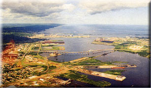
PHOTO: The Richard Bong Bridge over Lake
Superior in Duluth.
A 215-mile leg got me to Marquette, Michigan at dusk. I was
shivering when I got out of Miss P'fer. Why does it have to be so cold in July? I had a
shower in the firehouse, my first in three days and slept in the EAA Chapter 850
clubhouse. I was clean, warm and cozy. My Higher Power looked out for me again. Many
thanks to all those thoughtful, generous, caring people.
Day 34
By the time Miss P'fer was loaded, the airport restaurant was open.
I took off into a beautiful blue sky over the south shore of Lake Superior. The lake was
equally blue, ice blue. My heading was direct, cross-country to Sault Saint Marie,
Michigan. I remembered the swampy, tree-covered terrain of the Upper Peninsula from my
1989 flight in Cousin P'fer, my Kolb Firestar. I remembered staying right over the
highways all the way to Manistique, Michigan. It wasn't a good idea to stray too far way
from forced landing areas with the old 447.
I was just getting settled into my flight, thinking how well the 912
was doing its job when it picked up slight misfire. I was shocked back into the real
world. Automatically, Miss P'fer found her way, 4 or 5 miles, back to the highway. There,
a mag check indicated a weak plug on one side. I flew on to my destination.
At Sault Saint Marie, the Canadian Customs officials kept us waiting
an hour and a half. That gave me time to change spark plugs. Sure enough, the steady diet
of 100LL was taking its toll on the plugs. This set was installed on the pipeline haul
road, 60 miles south of Dead Horse. They lasted 75 hours. One plug was lead fouled. (Note:
I didn't throw these old plugs away. When I got home, I cleaned them with a straight pin,
small pocket knife and compressed air, put them back into service for another 127 hours
with no problem, operating primarily on 92 or 93 octane auto fuel. Only maintenance was
regapping every 50 hours. After 202 hours of service, there was no increase in performance
when new plugs were installed.)
I was anxious to fly. With the guidance from my little GPS, we flew
direct to Pembroke, 352 miles of trees, swamp and lakes. Pembroke's mosquitoes run a close
second to those in Alaska. I pitched my tent on a little patch of grass next to the
passenger terminal.
Day 35
I'm awakened by a tapping on my tent. I expected to find a policeman
telling me I'm trespassing. Instead I find an attractive young lady who inquired if I
would like a cup of coffee. WOW! Are you kidding! I think I RON'd at the right spot.
Inside the terminal, my coffee was waiting. I had breakfast and shared my adventure with
the airport employees.
I pointed Miss P'fer toward Ottawa and Montreal, then up the St.
Lawrence to Trois Rivieres. No one spoke English but me. We paralleled the St. Lawrence to
Quebec, then took a direct heading to Edmonston, NB and filed for Caribou, Maine port of
entry. Since it was after 1800 hours, I had to pay a $25.00 after hours fee. That hurt.
This guy was a retired Air Force NCO. I thought he might give me a break.
Flew direct to Millinocket and saw a Cub with floats out on the
horizon to my left. He was having a good time, but it turned out to be an N-3 Pup on its
maiden flight over the north woods of Maine.
Day 36
The gods smiled on me with abundant sunshine and a 15-20 mph
headwind. Bumpy and slow, but at least it was warm. Out of Maine into suburbia.
Massachusetts, Connecticut, New York, New Jersey, Pennsylvania are like one big city. I
pushed headwinds all the way to Homer Kolb's aircraft company in Spring City,
Pennsylvania. I took a couple of days to recoup, do laundry and check out Miss P'fer,
including a second oil and filter change. We were 200 hours into our trip.
Day 38
FSS indicated bad weather headed toward Philadelphia. It was two
weeks until Oshkosh. I didn't want to be late. I loaded up and departed Homer's and headed
south through Delaware and Maryland onto Al Carpenter's at Hudgen's Farm, Virginia. I took
on 14 gallons of Amoco 93 octane with Al's help from the nearby convenience store. Al
wanted me to spend the night and attend their local UL meeting that night but I was
homesick and headed south.
PHOTOS: (Right) Al Carpenter's flight farm,
Hudgins Farm, near Hampton, Virginia.
(Below left) Miss P'fer at Kill Devil Hill, North Carolina. We had to visit
where it all started.
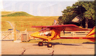 We pushed on to Kitty Hawk. I thought it
appropriate to pay my respects to the gentlemen and the place where aviation took its
first step. It was a moving experience to stand at the bottom of Kill Devil Hill. How far
we have come. How privileged we are to be able to build airplanes at home and fly them
with almost complete freedom when and where we wish. We pushed on to Kitty Hawk. I thought it
appropriate to pay my respects to the gentlemen and the place where aviation took its
first step. It was a moving experience to stand at the bottom of Kill Devil Hill. How far
we have come. How privileged we are to be able to build airplanes at home and fly them
with almost complete freedom when and where we wish.
Day 39
I wasted no time getting out of Plymouth, NC where I'd spent the
night. As I was gassing up in Wallace, North Carolina, I heard a voice holler, "I saw
that airplane in White Horse, Yukon Territory." Sure enough, it was one of the
Bonanza tour group. Small world.
The next leg was short, 65 miles. Somewhere near the NC/SC border I
noticed the outboard end of the right flap was hanging a little lower than the left. As I
suspected, the piano hinge pin had departed the aircraft. I punched nearest airport on the
GPS and landed at Loris, SC. Sam Sarvis was rocking in the shade of his front porch as I
taxied up to the FBO. He found me a piano hinge pin, then took me to lunch. I could have
stayed a while, but I was headed home. On down the Atlantic coast to Deland, Florida. I
was tired. Ate goodies from Miss P'fer's stash and slept under the wing.
 Day 40 Day 40
We broke ground as the sun broke the horizon. I flew to Lake
Okeechobee. Had breakfast and headed south to Homestead, my jumping off point for Key
West. I refueled from an old rusted out tank truck. The airport had been devastated by the
hurricane. I took on 15 gallons 100LL. The FBO wouldn't take my credit card; charged me
$20 cash for the fuel. That's a $1.33 a gallon; it was his way of supporting my flight,
even though he'd recently lost his business to weather.
PHOTO: This concrete pillar is all that
remained at Homestead AFB following the assault of Hurrican Andrew.
Filed for Key West 125 miles out to sea. Thank God for the Overseas
Highway. This was an exciting leg. I often dreamed of flying airplanes to Key West. It was
a beautiful flight over tropical islands; the opposite end of the spectrum from the
Arctic. Two different worlds. I was disappointed at the extra busy, commercial atmosphere
at the airport and decided not to stay, headed back north to Homestead. From across the
Everglades to La Belle for the night. My last night on the road was spent under Miss
P'fer's wing.
Day 41
17 July 1994 -- Unless I had some unforeseen problem, I would sleep
in my own bed tonight. We were up and out at first light, low leveling our way to the
Florida Flying Gators airfield. Visited a short while and then flew direct to my good
buddy Chuck Shaughnesy's airstrip at Branford. He was waiting. We had our traditional
lunch at Nell's cafe, stopped for auto gas and filled Miss P'fer for the last time. I was
350 miles from Gantt International Airport, Titus, Alabama. With stops at Thomasville,
Georgia and Eufaula and Tuskeegee, Alabama, I was almost home.
When I saw my eight-foot windsock (bigger than my airfield) in the
distance, those same tears that were here 41 days ago came back. I was overwhelmed with
emotion. My 85-year-old ultralight buddy, Ed Davis, had driven his Toyota up and down the
strip to knock down the high grass to help me land. My special friend, Nell, my son, Mike,
and Ernie, my Basset hound, were there also. I had to orbit the field to dry my eyes, then
Miss P'fer touched down and rolled out in front of the old T-hangar. She had brought me
home safe and sound.
 I had completed the adventure of a lifetime. I
have flown solo around the border of the continental United States, over parts of Mexico
(but didn't land), through five Canadian Provinces and Alaska. I emphasize, solo. Miss
P'fer and I were on our own from the time we left home until we returned. I flew this
flight just as I have since the first overnight cross country in my Kolb Firestar in 1987.
Fly until it's dark or I'm tired, or both, find an airport and spend the night. I had completed the adventure of a lifetime. I
have flown solo around the border of the continental United States, over parts of Mexico
(but didn't land), through five Canadian Provinces and Alaska. I emphasize, solo. Miss
P'fer and I were on our own from the time we left home until we returned. I flew this
flight just as I have since the first overnight cross country in my Kolb Firestar in 1987.
Fly until it's dark or I'm tired, or both, find an airport and spend the night.
PHOTO: Back home, safe and sound, in Titus,
Alabama.
None of this would have been possible completely on my own, however.
Though the flight was conducted by me and Miss P'fer, the preparation that led up to the
flight was accomplished by many. I cannot adequately express in words the gratitude I have
for my brother, Jim Hauck. Without his help, expertise, patience and untiring drive, there
would have been no highly modified Mark III to fly. He is responsible for the TIG welding
the entire airframe at the Kolb factory. He is responsible for all the design
modifications, with some engineering assistance from our good friend, Seth Mathews, on the
dual controls. Most of the time I came up with the requirement. Jim figured out how to and
did it.
I am extremely grateful to the following businesses who helped make
this flight possible: Kolb Aircraft; Second Chantz Recover Systems; Warp Drive Propellers;
Alexander Aeroplane Company; South Mississippi Light Aircraft. In addition, I am grateful
to my friends and relatives who accepted numerous collect, long-distance calls from as far
away as Dead Horse, Alaska.
Why did I build and modify this airplane, go to all the pains and
expense to prepare for and complete this particular bold adventure? I love the challenge
of extended cross country solo flight. I don't think anyone else has ever made this
particular flight in a home-made airplane. I wanted to show the world that we can do as
much or more with our little airplanes as could more sophisticated, general aviation
aircraft. I wanted to see and experience my country first hand, much of which I had never
seen before.
Eight days after returning from Alaska, I loaded Miss P'fer for the
flight to Oshkosh, another 2,000 miles up and back. In less than 60 days, she had flown
more than 19,400 miles and logged 260.1 hours.
I dedicated my adventure to everyone who dreams of doing something
like this, but can't for one reason or other. This has been my adventure of a lifetime. |
|
|
|
|
 |

|